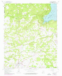
1963 Map of Quitman
USGS Topo · Published 1976About this map
Quitman sits at the southern edge of a landscape defined by the winding course of Cadron Creek and its many tributaries, captured here in the early 1960s with revisions reflecting the mid-1970s. The map illustrates the rising waters of Greers Ferry Lake as it reaches into Goff Cove, a significant change to the local topography. Away from the lake, the area retains a rural character marked by small settlements like Pearson and Crossroads.
Find a feature on this map
43 named features on this map. Tap any name to fly to it.
Don’t see what you’re looking for? This feature index may not catch every label — zoom into the map to look around manually.
Map Details
Editions of this 1963 Quitman Map
3 editions found
Other maps of this area

1892 · Mountain View
USGS Topo · 1:125,000

1894 · Mountain View
USGS Topo · 1:125,000

1956 · Russellville
USGS Topo · 1:250,000

1961 · Bee Branch
USGS Topo · 1:62,500

1961 · Morganton
USGS Topo · 1:24,000

1961 · Guy
USGS Topo · 1:24,000

1963 · Rose Bud
USGS Topo · 1:24,000

1963 · Quitman
USGS Topo · 1:24,000
1963 · Barney
USGS Topo · 1:24,000
1963 · Heber Springs
USGS Topo · 1:24,000