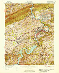
1950 Map of Radford
USGS Topo · Published 1952About this map
The New River carves a dramatic path through the ridge-and-valley landscape of southwest Virginia, serving as the industrial and topographic anchor for this mid-century survey. The massive Claytor Lake impoundment is a central feature, held back by the Claytor Dam and bordered by Claytor Lake State Park. Along the river's northern bend, the Radford Arsenal occupies a sprawling loop, while the city of Radford itself sits at a critical junction where the Norfolk and Western and Virginian railroads meet.
Find a feature on this map
93 named features on this map. Tap any name to fly to it.
Don’t see what you’re looking for? This feature index may not catch every label — zoom into the map to look around manually.
Map Details
Editions of this 1950 Radford Map
3 editions found

Other maps of this area

1889 · Hillsville
USGS Topo · 1:125,000

1890 · Dublin
USGS Topo · 1:125,000

1890 · Christiansburg
USGS Topo · 1:125,000

1891 · Dublin
USGS Topo · 1:125,000

1892 · Hillsville
USGS Topo · 1:125,000

1896 · Hillsville
USGS Topo · 1:125,000

1913 · Peterstown
USGS Topo · 1:48,000

1916 · Peterstown
USGS Topo · 1:62,500

1923 · Pearisburg
USGS Topo · 1:62,500

1923 · Waiteville
USGS Topo · 1:62,500