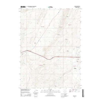
2015 Map of Ragan
USGS Topo · Published 2015About this map
Ragan sits at the heart of this high-plains landscape in Uinta County, where the high desert meets the ridge lines of the Overthrust Belt. The topography is defined by sharp elevation shifts across The Hogsback and Pine Ridge, while a series of deep drainages like Coal Mine Draw and Wasmer Draw illustrate the area's resource extraction history. Grounded in local heritage, the Spring Valley Cem is located in the southern reaches near Antelope Cr, marking a quiet record of early settlers. A network of county roads, including Piedmont Rd and Bar Hat Rd, crisscross the terrain to connect remote landmarks like Bald Knoll and the water source at Mineral Springs. The map also captures the local hydrography through several seasonal flows, such as Byrne Cr and Hinshaw Cr, which historically dictated movement through the high country.
Find a feature on this map
35 named features on this map. Tap any name to fly to it.
Don’t see what you’re looking for? This feature index may not catch every label — zoom into the map to look around manually.
Map Details
Editions of this 2015 Ragan Map
This is the sole edition of this map. No revisions or reprints were ever made.
Other maps of this area

1954 · Ogden
USGS Topo · 1:250,000

1958 · Ogden
USGS Topo · 1:250,000

1960 · Ogden
USGS Topo · 1:250,000

1965 · Bridger
USGS Topo · 1:24,000

1965 · Ragan
USGS Topo · 1:24,000

1965 · Leroy
USGS Topo · 1:24,000

1965 · Little Dee Creek
USGS Topo · 1:24,000

1965 · Meadow Draw
USGS Topo · 1:24,000

1965 · Sulphur Creek Reservoir
USGS Topo · 1:24,000
1965 · Hague Creek
USGS Topo · 1:24,000