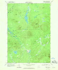
1968 Map of Ragged Lake
USGS Topo · Published 1970About this map
Bryants Mill and the industrial remnants of the Upper Kilns and Middle Kilns speak to the heritage of logging and resource extraction within this portion of the Adirondack State Park. Surveyed in the late 1960s, the landscape is defined by its complex hydrology, where Ragged Lake feeds into the Outlet and the Salmon River drainage. Evidence of former transport networks is visible through the Old Railroad Grade and Railroad Grade that snake through the Plumadore Range. These routes once connected remote mountain outposts and milling operations, now surrounded by a dense network of peaks including Ragged Lake Mtn, Sugarloaf Mtn, and Whipple Hill. The topographic detail highlights specialized features like The Beaver Dam on the Brook and the narrow passage at The Narrows, reflecting the intricate terrain of the State Forest Preserve in Franklin and Bellmont.
Find a feature on this map
54 named features on this map. Tap any name to fly to it.
Don’t see what you’re looking for? This feature index may not catch every label — zoom into the map to look around manually.
Map Details
Editions of this 1968 Ragged Lake Map
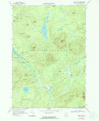
2 editions found
Other maps of this area

1906 · Loon Lake
USGS Topo · 1:62,500

1908 · Loon Lake
USGS Topo · 1:62,500

1911 · Lyon Mountain
USGS Topo · 1:62,500

1913 · Lyon Mountain
USGS Topo · 1:62,500

1915 · Churubusco
USGS Topo · 1:62,500

1915 · Chateaugay
USGS Topo · 1:62,500

1931 · Lyon Mountain
USGS Topo · 1:62,500

1943 · Churubusco
USGS Topo · 1:62,500

1943 · Chateaugay
USGS Topo · 1:62,500

1948 · Ogdensburg
USGS Topo · 1:250,000