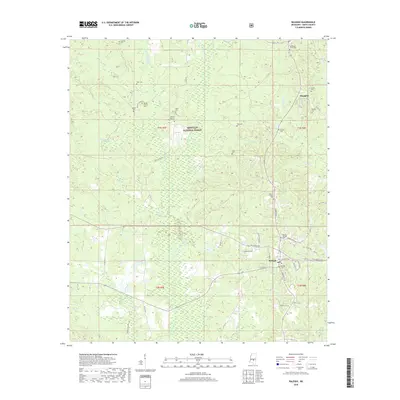
2018 Map of Raleigh
USGS Topo · Published 2018About this map
Raleigh serves as the focal point of this Smith County survey, where residential streets like White Oak Ave and Sylvarena Ave meet near the Raleigh Cemetery. The surrounding landscape is defined by the dense woodlands of the Bienville National Forest, a patchwork of timberland and creek bottoms. The area is heavily intersected by small watercourses including Oakohay Creek, Little Oakohay Creek, and Shongelo Creek, which drains from Shongelo Lake.
Find a feature on this map
61 named features on this map. Tap any name to fly to it.
Don’t see what you’re looking for? This feature index may not catch every label — zoom into the map to look around manually.
Map Details
Editions of this 2018 Raleigh Map
This is the sole edition of this map. No revisions or reprints were ever made.
Other maps of this area

1935 · White Oak
USGS Topo · 1:24,000

1953 · Hattiesburg
USGS Topo · 1:250,000

1953 · Meridian
USGS Topo · 1:250,000

1957 · Meridian
USGS Topo · 1:250,000

1958 · Hattiesburg
USGS Topo · 1:250,000

1965 · Meridian
USGS Topo · 1:250,000

1968 · Pineville
USGS Topo · 1:24,000
1968 · Homewood
USGS Topo · 1:24,000

1968 · White Oak
USGS Topo · 1:24,000
1968 · Polkville
USGS Topo · 1:24,000