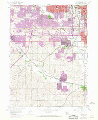
1956 Map of Ralston
USGS Topo · Published 1970About this map
The renowned community of Boys Town and the expanding suburbs of Omaha define this mid-century portrait of eastern Nebraska. The landscape is a complex intersection of historic rail corridors and post-war residential growth, as seen in the purple-tinted urban extensions of Ralston, La Vista, and Papillion. Transportation routes are foundational here, with the Union Pacific and Chicago Burlington and Quincy railroads threading through the valleys of West Papillion Creek and Big Papillion Creek. Local genealogy and civic history are preserved in the numerous named educational and memorial sites, including Westside High School, Bloomfield School, and the extensive grounds of Calvary Cemetery. The transition from rural to suburban is further evidenced by the presence of both the South Omaha Airport and specialized recreational landmarks like Ak-Sar-Ben Field.
Find a feature on this map
53 named features on this map. Tap any name to fly to it.
Don’t see what you’re looking for? This feature index may not catch every label — zoom into the map to look around manually.
Map Details
Editions of this 1956 Ralston Map
5 editions found
Other maps of this area

1893 · Omaha
USGS Topo · 1:62,500

1893 · Fremont
USGS Topo · 1:125,000

1896 · Fremont
USGS Topo · 1:125,000

1954 · Omaha
USGS Topo · 1:250,000

1955 · Fremont
USGS Topo · 1:250,000

1956 · Gretna
USGS Topo · 1:24,000

1956 · Cedar Creek
USGS Topo · 1:24,000

1956 · Ralston
USGS Topo · 1:24,000

1956 · Springfield
USGS Topo · 1:24,000

1956 · Irvington
USGS Topo · 1:24,000