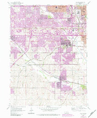
1956 Map of Ralston
USGS Topo · Published 1984About this map
Omaha and its western suburbs undergo a transformative period of growth on this sheet, which combines original 1950s survey data with 1980s urban revisions. The landscape is defined by the convergence of the Union Pacific, Burlington Northern, and Missouri Pacific railroads, which weave through the valleys of the Big Papillion Creek and West Papillion Creek. This transit-oriented development is visible in the burgeoning residential corridors of Ralston and La Vista, while older rural signatures like the Prairie Queen Sch and Ireland Sch reflect the area's agricultural roots.
Find a feature on this map
47 named features on this map. Tap any name to fly to it.
Don’t see what you’re looking for? This feature index may not catch every label — zoom into the map to look around manually.
Map Details
Editions of this 1956 Ralston Map
5 editions found
Other maps of this area

1893 · Omaha
USGS Topo · 1:62,500

1893 · Fremont
USGS Topo · 1:125,000

1896 · Fremont
USGS Topo · 1:125,000

1954 · Omaha
USGS Topo · 1:250,000

1955 · Fremont
USGS Topo · 1:250,000

1956 · Gretna
USGS Topo · 1:24,000

1956 · Cedar Creek
USGS Topo · 1:24,000

1956 · Ralston
USGS Topo · 1:24,000

1956 · Springfield
USGS Topo · 1:24,000

1956 · Irvington
USGS Topo · 1:24,000