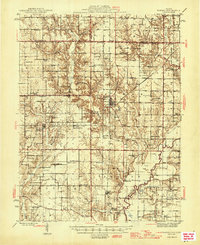
1946 Map of Ramsey
USGS Topo · Published 1946About this map
The Kaskaskia River winds through the southeastern corner of this Fayette County landscape, anchored by the rail junctions at Ramsey and Bingham. At this time in the mid-1940s, the rural character is defined by a dense network of country schools and family burial grounds, including the Hoffman Cem, Shed Cem, and Oak Grove Cem. Education and faith were local cornerstones, evidenced by uniquely named sites like Brush College Sch, Little Democracy Sch, and Halford Chapel.
Find a feature on this map
102 named features on this map. Tap any name to fly to it.
Don’t see what you’re looking for? This feature index may not catch every label — zoom into the map to look around manually.
Map Details
Editions of this 1946 Ramsey Map
2 editions found

Other maps of this area

1932 · Greenville
USGS Topo · 1:62,500

1939 · Greenville
USGS Topo · 1:62,500

1941 · St. Elmo
USGS Topo · 1:62,500

1942 · Shelbyville
USGS Topo · 1:62,500

1943 · Greenville
USGS Topo · 1:62,500

1944 · Ramsey
USGS Topo · 1:62,500

1945 · St. Elmo
USGS Topo · 1:62,500

1945 · Kinmundy
USGS Topo · 1:62,500

1945 · Vandalia
USGS Topo · 1:62,500

1946 · Shelbyville
USGS Topo · 1:62,500