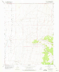
1958 Map of Ranch Canyon
USGS Topo · Published 1975About this map
The Escalante Desert floor meets the rising foothills of Beaver County in this mid-century topographic survey. A stark contrast exists between the flat western expanse and the deeply cut drainages to the east, notably Ranch Canyon and Corral Canyon. The arrival of the Union Pacific railroad and the presence of the Milford City Bdy in the southwest corner indicate the area's development as a transportation and utility corridor. Water management is a central theme of the landscape, evidenced by the Beaver River and a network of irrigation works including the High Line Canal and The Canal. These features, along with the Yellow Banks, highlight the efforts to harness the region's limited resources for agricultural or industrial use. High-clearance routes like the Corral Canyon Jeep Trail provide the primary access into the rugged eastern terrain.
Find a feature on this map
17 named features on this map. Tap any name to fly to it.
Don’t see what you’re looking for? This feature index may not catch every label — zoom into the map to look around manually.
Map Details
Editions of this 1958 Ranch Canyon Map
3 editions found
Other maps of this area

1885 · Beaver
USGS Topo · 1:250,000

1953 · Milford Flat
USGS Topo · 1:24,000

1953 · Cave Canyon
USGS Topo · 1:24,000

1953 · Richfield
USGS Topo · 1:250,000

1958 · Richfield
USGS Topo · 1:250,000

1958 · Milford
USGS Topo · 1:62,500

1958 · Milford
USGS Topo · 1:24,000

1958 · Adamsville
USGS Topo · 1:62,500

1958 · Ranch Canyon
USGS Topo · 1:24,000

1960 · Beaver Lake Mts.
USGS Topo · 1:62,500