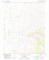
1958 Map of Ranch Canyon
USGS Topo · Published 1991About this map
The Escalante Desert dominates this landscape, showing a transition from the arid basin floor to the rising topography of the eastern canyons. In the late 1950s, water management was central to the region's character, evidenced by The Low Line Canal and Pass Road Canal cutting across the desert floor to support local agriculture. The Beaver River winds through the western portion of the sheet, creating the Beaver Bottoms and passing the distinctive Yellow Banks.
Find a feature on this map
18 named features on this map. Tap any name to fly to it.
Don’t see what you’re looking for? This feature index may not catch every label — zoom into the map to look around manually.
Map Details
Editions of this 1958 Ranch Canyon Map
3 editions found
Other maps of this area

1885 · Beaver
USGS Topo · 1:250,000

1953 · Milford Flat
USGS Topo · 1:24,000

1953 · Cave Canyon
USGS Topo · 1:24,000

1953 · Richfield
USGS Topo · 1:250,000

1958 · Richfield
USGS Topo · 1:250,000

1958 · Milford
USGS Topo · 1:62,500

1958 · Milford
USGS Topo · 1:24,000

1958 · Adamsville
USGS Topo · 1:62,500

1958 · Ranch Canyon
USGS Topo · 1:24,000

1960 · Beaver Lake Mts.
USGS Topo · 1:62,500