
1910 Map of Rangely
USGS Topo · Published 1910About this map
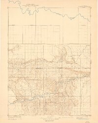
White River flows through the southern heart of this territory, where the early settlement of Rangely sits amidst the vast terrain of Raven Park. Surveyed in 1907 by Hoyt S. Gale, John Allen Davis, and Charles W. Stoops, this reconnaissance map illustrates the land shortly after the turn of the century, capturing a region defined by its watercourses and prominent landforms. To the north, the Yampa River snakes across the landscape, while the Routt Co Rio Blanco Co Boundary Line bisects the rugged topography of the central section. Small outposts such as Angora, Boxelder, and Three Springs are documented alongside natural landmarks like Cathedral Bluffs and Raven Ridge. The detailed drainage patterns of Skull Creek, Red Wash, and Stinking Creek reflect the meticulous field work required for this USGS Bulletin 415 reprint.
Find a feature on this map
17 named features on this map. Tap any name to fly to it.
Don’t see what you’re looking for? This feature index may not catch every label — zoom into the map to look around manually.
Map Details
Editions of this 1910 Rangely Map
2 editions found
Other maps of this area

1885 · East Tavaputs
USGS Topo · 1:250,000

1885 · Ashley
USGS Topo · 1:250,000

1907 · Rangely
USGS Topo · 1:125,000

1907 · Jensen
USGS Topo · 1:125,000

1907 · White River
USGS Topo · 1:125,000

1910 · Jensen
USGS Topo · 1:125,000

1910 · White River
USGS Topo · 1:125,000

1952 · Wolf Ridge
USGS Topo · 1:24,000

1954 · Hells Canyon
USGS Topo · 1:24,000

1954 · Canyon of Lodore South
USGS Topo · 1:24,000