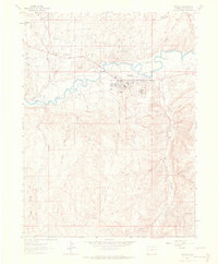
1962 Map of Rangely
USGS Topo · Published 1965About this map
The Rangely Oil Field dominates this early 1960s landscape, illustrating a high-desert industrial boom centered on the White River. The area is characterized by a dense network of energy infrastructure, including numerous Oil Wells, a Power Plant, and a complex system of pipelines crossing the Coal Oil Basin. Beyond the primary townsite of Rangely, the map reveals several industrial housing clusters or company outposts such as California Camp, Sharples Camp, and Texas Camp, which provided essential proximity for workers in this remote extraction zone. Geologic and hydrologic features like the Coal Oil Rim and Douglas Creek frame the activity, while local civic life is represented by St Timothy church, a Jr High Sch, and the local Hospital. The map captures a specific moment when the regional economy was tied deeply to the subterranean riches of Rio Blanco County.
Find a feature on this map
41 named features on this map. Tap any name to fly to it.
Don’t see what you’re looking for? This feature index may not catch every label — zoom into the map to look around manually.
Map Details
Editions of this 1962 Rangely Map
4 editions found
Other maps of this area

1907 · Rangely
USGS Topo · 1:125,000

1910 · Rangely
USGS Topo · 1:125,000

1954 · Vernal
USGS Topo · 1:250,000

1956 · Grand Junction
USGS Topo · 1:250,000

1958 · Vernal
USGS Topo · 1:250,000

1959 · Grand Junction
USGS Topo · 1:250,000

1960 · Vernal
USGS Topo · 1:250,000

1960 · Grand Junction
USGS Topo · 1:250,000

1962 · Grand Junction
USGS Topo · 1:250,000

1962 · Rangely NE
USGS Topo · 1:24,000