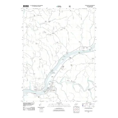
2011 Map of Raven Rock
USGS Topo · Published 2011About this map
Saint Marys and Newport anchor this riverine corridor where the Ohio River separates West Virginia and Ohio. The landscape is defined by its relationship to the water, featuring a specialized Saint Marys Seaplane Base and the Hi Carpenter Memorial Bridge connecting the two states. The mapping detail reveals a dense network of family and community landmarks, including the Independent Order of Odd Fellows Cemetery and the German Cemetery on Bell Ridge. Historical landings like Schoosters Landing and Murphys Landing dot the banks near Grape Island and Middle Island, reflecting the river's enduring role in local transport. Inland, the terrain rises into ridges and hollows like Barnes Hollow and Pine Ridge, where small settlements such as Archers Fork and Deucher persist along winding township roads.
Find a feature on this map
101 named features on this map. Tap any name to fly to it.
Don’t see what you’re looking for? This feature index may not catch every label — zoom into the map to look around manually.
Map Details
Editions of this 2011 Raven Rock Map
This is the sole edition of this map. No revisions or reprints were ever made.
Other maps of this area

1903 · Macksburg
USGS Topo · 1:62,500

1904 · Marietta
USGS Topo · 1:62,500

1905 · New Matamoras
USGS Topo · 1:62,500

1905 · Macksburg
USGS Topo · 1:62,500

1906 · Saint Marys
USGS Topo · 1:62,500

1924 · St Marys
USGS Topo · 1:62,500

1924 · New Matamoras
USGS Topo · 1:62,500

1924 · Marietta
USGS Topo · 1:62,500

1926 · New Matamoras
USGS Topo · 1:62,500

1927 · Marietta
USGS Topo · 1:62,500