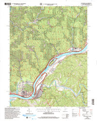
2002 Map of Raven Rock
USGS Topo · Published 2006About this map
The Ohio River defines the central character of this river-valley landscape, serving as the border between Washington County, Ohio, and Pleasants County, West Virginia. The bustling riverfront at St Marys and the town of Newport anchor the southern reaches, while the river's channel is marked by the Ohio River Islands National Wildlife Refuge, including Grape Island and Middle Island. Away from the water, the terrain rises into prominent ridges such as Carmel Ridge and Pine Ridge, where small rural communities like Deucher and Archers Fork are found alongside numerous family burial grounds, including the German Cem and Taylor Cem. The map illustrates a landscape of institutional and recreational spaces, from the State Training Sch and Golf Course near the river to the protected acreage of the Wayne National Forest in the north.
Find a feature on this map
56 named features on this map. Tap any name to fly to it.
Don’t see what you’re looking for? This feature index may not catch every label — zoom into the map to look around manually.
Map Details
Editions of this 2002 Raven Rock Map
This is the sole edition of this map. No revisions or reprints were ever made.
Other maps of this area

1903 · Macksburg
USGS Topo · 1:62,500

1904 · Marietta
USGS Topo · 1:62,500

1905 · New Matamoras
USGS Topo · 1:62,500

1905 · Macksburg
USGS Topo · 1:62,500

1906 · Saint Marys
USGS Topo · 1:62,500

1924 · St Marys
USGS Topo · 1:62,500

1924 · New Matamoras
USGS Topo · 1:62,500

1924 · Marietta
USGS Topo · 1:62,500

1926 · New Matamoras
USGS Topo · 1:62,500

1927 · Marietta
USGS Topo · 1:62,500