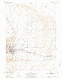
1953 Map of Rawlins
USGS Topo · Published 1976About this map
The State Penitentiary anchor the western edge of Rawlins, a town defined by its role as a transportation hub during the mid-twentieth century. This survey showcases the dense infrastructure of the Union Pacific railroad corridor and the Lincoln Highway as they cut through the valley of Sugar Creek. The town's civic life is well-documented through a network of local institutions, including St Joseph Sch, Pershing Sch, and Mountainview Sch, alongside the prominent Rawlins Cemetery. Outside the city limits, the landscape transitions into a utilitarian mix of industry and recreation, featuring the Rawlins Airport, the Solfour Ranch, and numerous quarries. An interesting glimpse of mid-century Americana is found east of town at the Drive-in Theater, while a Pedestrian Underpass near the town center speaks to the local navigation of the busy rail lines.
Find a feature on this map
30 named features on this map. Tap any name to fly to it.
Don’t see what you’re looking for? This feature index may not catch every label — zoom into the map to look around manually.
Map Details
Editions of this 1953 Rawlins Map
4 editions found
Other maps of this area

1953 · Sinclair
USGS Topo · 1:24,000

1953 · Rawlins
USGS Topo · 1:24,000

1953 · Lone Haystack Mountain
USGS Topo · 1:24,000

1953 · Rawlins NW
USGS Topo · 1:24,000

1954 · Rawlins
USGS Topo · 1:250,000

1956 · Rawlins Peak
USGS Topo · 1:62,500

1956 · Bridger Pass
USGS Topo · 1:62,500

1956 · Bolten Ranch
USGS Topo · 1:62,500

1958 · Rawlins
USGS Topo · 1:250,000

1962 · Rawlins
USGS Topo · 1:250,000