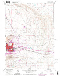
1953 Map of Rawlins
USGS Topo · Published 1981About this map
The high plains landscape of Rawlins is dominated by the strategic intersection of the Union Pacific railroad and the burgeoning mid-century aviation infrastructure at Rawlins Municipal Airport. This 1953 survey, with updates reflecting the town's expansion into the 1980s, captures the community as it grew around the massive State Penitentiary and the residential corridors of Sunnyside. Educational and civic life are anchored by several local schools, including St Joseph Sch and Mountainview Sch, while the outskirts are marked by industrial activity like Quarries and Gravel Pits. The topography is defined by the drainage of Sugar Creek and Coal Creek, illustrating the town's reliance on these watercourses and the surrounding ridges. Extensive networks of pipelines crossing the territory highlight the importance of energy infrastructure in this part of Carbon County during the post-war era.
Find a feature on this map
25 named features on this map. Tap any name to fly to it.
Don’t see what you’re looking for? This feature index may not catch every label — zoom into the map to look around manually.
Map Details
Editions of this 1953 Rawlins Map
4 editions found
Other maps of this area

1953 · Sinclair
USGS Topo · 1:24,000

1953 · Rawlins
USGS Topo · 1:24,000

1953 · Lone Haystack Mountain
USGS Topo · 1:24,000

1953 · Rawlins NW
USGS Topo · 1:24,000

1954 · Rawlins
USGS Topo · 1:250,000

1956 · Rawlins Peak
USGS Topo · 1:62,500

1956 · Bridger Pass
USGS Topo · 1:62,500

1956 · Bolten Ranch
USGS Topo · 1:62,500

1958 · Rawlins
USGS Topo · 1:250,000

1962 · Rawlins
USGS Topo · 1:250,000