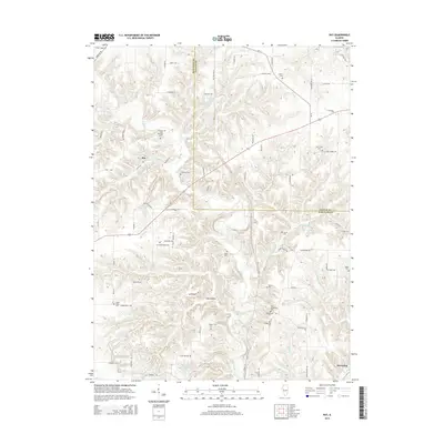
2015 Map of Ray
USGS Topo · Published 2015About this map
Browning and Ray anchor this 2015 study of the borderlands between Schuyler and Fulton Counties. The terrain is defined by the winding course of Sugar Creek and numerous drainages like Harris Branch and McKee Branch, which carve through the landscape to create distinctive formations like Scab Hollow and Devils Backbone. Genealogists will find a high density of burial sites across the township lines, ranging from Christian Neck Cemetery to the dual sites of Old Ridgeville Cemetery and New Ridgeville Cemetery. This distribution of family and community cemeteries, such as Pittenger Cemetery and Burress Cemetery, suggests a long-established pattern of rural settlement. The presence of Peabody Lake and Sullivan Lake provides contrast to the agricultural and creek-bottom lands that dominate the region's geography.
Find a feature on this map
80 named features on this map. Tap any name to fly to it.
Don’t see what you’re looking for? This feature index may not catch every label — zoom into the map to look around manually.
Map Details
Editions of this 2015 Ray Map
This is the sole edition of this map. No revisions or reprints were ever made.
Other maps of this area

1912 · Macomb
USGS Topo · 1:62,500

1914 · Macomb
USGS Topo · 1:62,500

1918 · Vermont
USGS Topo · 1:62,500

1921 · Vermont
USGS Topo · 1:62,500

1923 · Rushville
USGS Topo · 1:62,500

1926 · Beardstown
USGS Topo · 1:62,500

1926 · Rushville
USGS Topo · 1:62,500

1944 · Beardstown
USGS Topo · 1:62,500

1947 · Vermont
USGS Topo · 1:24,000
1948 · Vermont
USGS Topo · 1:24,000