
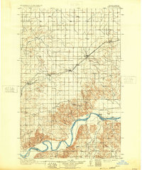
1911 Map of Ray
USGS Topo · Published 1911About this map
The Missouri River snakes through the southern portion of this region, serving as a boundary between Williams Co and McKenzie Co. Along the river's northern bank, the settlement of Nesson and the Nesson Ferry highlight the early importance of river-based transit in this frontier landscape. To the north, the corridor of the Great Northern railroad dictates the pattern of development, with a string of communities established along the tracks, including Ray, Wheelock, Epping, and Spring Brook.
Find a feature on this map
28 named features on this map. Tap any name to fly to it.
Don’t see what you’re looking for? This feature index may not catch every label — zoom into the map to look around manually.
Map Details
Editions of this 1911 Ray Map
2 editions found
Other maps of this area

1953 · Williston
USGS Topo · 1:250,000

1953 · Watford City
USGS Topo · 1:250,000

1957 · Williston
USGS Topo · 1:250,000

1957 · Watford City
USGS Topo · 1:250,000

1959 · Marmon SE
USGS Topo · 1:24,000

1959 · Williston East
USGS Topo · 1:24,000

1965 · Keene
USGS Topo · 1:24,000

1965 · Charlson SW
USGS Topo · 1:24,000

1965 · Charlson NW
USGS Topo · 1:24,000

1967 · Watford City
USGS Topo · 1:250,000