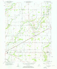
1956 Map of Rays Crossing
USGS Topo · Published 1958About this map
Rays Crossing serves as a focal point for this agrarian landscape in central Shelby County, where the Pennsylvania railroad cuts a diagonal line across the section grid. This 1950s survey documents a well-distributed network of community centers, including Township Sch and several country churches like Mt Pisgah Ch and Zion Ch. The rural economy of the era is evident in the Grain Storage Bins situated near the tracks and various Gas Wells scattered throughout the townships of Addison, Liberty, and Union.
Find a feature on this map
33 named features on this map. Tap any name to fly to it.
Don’t see what you’re looking for? This feature index may not catch every label — zoom into the map to look around manually.
Map Details
Editions of this 1956 Rays Crossing Map
5 editions found
Other maps of this area

1942 · Columbus
USGS Topo · 1:125,000

1948 · Lewis Creek
USGS Topo · 1:24,000

1950 · Edinburg
USGS Topo · 1:62,500

1952 · Fountaintown
USGS Topo · 1:24,000

1953 · Shelbyville
USGS Topo · 1:24,000

1953 · Cincinnati
USGS Topo · 1:250,000

1956 · Morristown
USGS Topo · 1:24,000

1956 · Waldron
USGS Topo · 1:24,000

1956 · Rays Crossing
USGS Topo · 1:24,000

1957 · Cincinnati
USGS Topo · 1:250,000