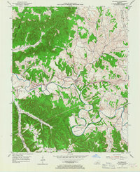
1953 Map of Raywick
USGS Topo · Published 1967About this map
Raywick sits at a strategic bend in the Rolling Fork, where the river's meandering course creates distinctive features like Horseshoe Bend. During this era of the early 1950s, the landscape was a mix of wooded uplands and fertile bottomlands defined by local industry and Catholic heritage, seen in the presence of the St Francis Xavier (Cath) church in Raywick and the nearby settlement of Saint Francis. The agricultural character of the region is punctuated by a Distillery along the river, while rural life is anchored by several local institutions including Highview Sch and Mt Washington Sch. Further south, Scotts Millen Ridge rises above the valley, and the Louisville and Nashville railroad tracks cut through the northeast corner, facilitating the movement of goods and passengers through this part of Marion County.
Find a feature on this map
28 named features on this map. Tap any name to fly to it.
Don’t see what you’re looking for? This feature index may not catch every label — zoom into the map to look around manually.
Map Details
Editions of this 1953 Raywick Map
3 editions found
Other maps of this area

1953 · Howardstown
USGS Topo · 1:24,000

1953 · Loretto
USGS Topo · 1:24,000

1953 · Saloma
USGS Topo · 1:24,000

1953 · Hibernia
USGS Topo · 1:24,000

1953 · Saint Catharine
USGS Topo · 1:24,000

1953 · New Haven
USGS Topo · 1:24,000

1953 · Raywick
USGS Topo · 1:24,000

1953 · Spurlington
USGS Topo · 1:24,000

1953 · Lebanon West
USGS Topo · 1:24,000

1957 · Winchester
USGS Topo · 1:250,000