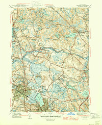
1944 Map of Reading
USGS Topo · Published 1944About this map
Quannapowitt Lake and the Ipswich River basin define the landscape of this mid-century survey, where the expanding residential grids of Reading and Wakefield meet the wetlands and military training grounds of Essex and Middlesex Counties. The map reveals a transition from the village center of North Reading to specialized land uses, including the Military Police Camp and the expansive Rifle Range at Camp Curtis Guild. Numerous cemeteries like Puritan Lawn Cemetery and the Flint Burying Ground are recorded, providing vital locations for genealogists.
Find a feature on this map
87 named features on this map. Tap any name to fly to it.
Don’t see what you’re looking for? This feature index may not catch every label — zoom into the map to look around manually.
Map Details
Editions of this 1944 Reading Map
2 editions found
Other maps of this area

1886 · Lawrence
USGS Topo · 1:62,500

1888 · Lawrence
USGS Topo · 1:62,500

1888 · Salem
USGS Topo · 1:62,500

1892 · Boston Bay
USGS Topo · 1:62,500

1893 · Salem
USGS Topo · 1:62,500

1893 · Boston
USGS Topo · 1:62,500

1893 · Lawrence
USGS Topo · 1:62,500

1903 · Boston
USGS Topo · 1:62,500

1903 · Boston Bay
USGS Topo · 1:62,500

1917 · Salem
USGS Topo · 1:62,500