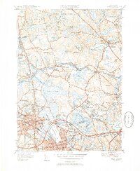
1951 Map of Reading
USGS Topo · Published 1952About this map
Camp Curtis Guild and a dedicated Military Police Camp dominate the central landscape of this mid-century survey, illustrating the area's significance for regional defense and training. The terrain is characterized by a dense network of water bodies and wetlands, notably the expansive Cedar Swamp and Lake Quannapowitt, which serve as natural boundaries between the developing suburban centers of Reading, Wakefield, and North Reading. The Ipswich River meanders across the upper portion of the map, while the Boston and Maine Railroad provides the primary industrial and transit spine for these North Shore communities.
Find a feature on this map
85 named features on this map. Tap any name to fly to it.
Don’t see what you’re looking for? This feature index may not catch every label — zoom into the map to look around manually.
Map Details
Editions of this 1951 Reading Map
3 editions found
Other maps of this area

1886 · Lawrence
USGS Topo · 1:62,500

1888 · Lawrence
USGS Topo · 1:62,500

1888 · Salem
USGS Topo · 1:62,500

1892 · Boston Bay
USGS Topo · 1:62,500

1893 · Salem
USGS Topo · 1:62,500

1893 · Boston
USGS Topo · 1:62,500

1893 · Lawrence
USGS Topo · 1:62,500

1903 · Boston
USGS Topo · 1:62,500

1903 · Boston Bay
USGS Topo · 1:62,500

1917 · Salem
USGS Topo · 1:62,500