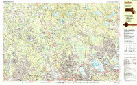
1987 Map of Reading
USGS Topo · Published 1987About this map
The Ipswich River snakes through this 1980s landscape at the junction of Middlesex and Essex Counties, revealing a region defined by post-war suburban density and significant institutional land use. Large protected areas like the Harold Parker State Forest and the Camp Curtis Guild National Guard Reservation provide a stark contrast to the tightly gridded residential streets of Reading, Wilmington, and Wakefield. This era shows the mature development of the local infrastructure, from the industrial Gravel Pits and quarries to the extensive school systems including Shawsheen Valley Vo-Tech High Sch and Austin Sch.
Find a feature on this map
129 named features on this map. Tap any name to fly to it.
Don’t see what you’re looking for? This feature index may not catch every label — zoom into the map to look around manually.
Map Details
Editions of this 1987 Reading Map
2 editions found
Other maps of this area

1886 · Lawrence
USGS Topo · 1:62,500

1886 · Lowell
USGS Topo · 1:62,500

1886 · Framingham
USGS Topo · 1:62,500

1888 · Lawrence
USGS Topo · 1:62,500

1888 · Salem
USGS Topo · 1:62,500

1889 · Framingham
USGS Topo · 1:62,500

1892 · Boston Bay
USGS Topo · 1:62,500

1893 · Lowell
USGS Topo · 1:62,500

1893 · Salem
USGS Topo · 1:62,500

1893 · Boston
USGS Topo · 1:62,500