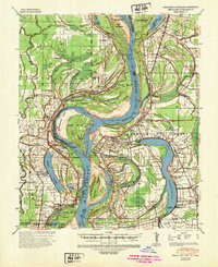
1939 Map of Readland
USGS Topo · Published 1947About this map
The Mississippi River dominates this landscape along the Arkansas-Louisiana-Mississippi border, defined by a complex network of meander scars and cut-offs. The legacy of hydraulic engineering is evident in features like the American Cut-Off 1858 and the Grand Lake Cut-Off 1796-1817, which reflect over a century of efforts to tame the river's course. Numerous river landings such as Princeton Ldg, Seven Oaks Ldg, and Longwood Ldg suggest a period when river-borne commerce was central to local life, connecting inland settlements to the broader world.
Find a feature on this map
89 named features on this map. Tap any name to fly to it.
Don’t see what you’re looking for? This feature index may not catch every label — zoom into the map to look around manually.
Map Details
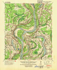
Editions of this 1939 Readland Map
3 editions found
Other maps of this area

1909 · Wilsons Point
USGS Topo · 1:24,000

1909 · Millikin
USGS Topo · 1:24,000

1909 · Ashton Bridge
USGS Topo · 1:24,000

1912 · Ashton Bridge
USGS Topo · 1:31,680

1913 · Wilson Point
USGS Topo · 1:31,680

1935 · Oak Grove
USGS Topo · 1:62,500

1936 · Eudora
USGS Topo · 1:62,500

1936 · Lake Village
USGS Topo · 1:62,500

1939 · Lorenzen
USGS Topo · 1:62,500

1939 · Readland
USGS Topo · 1:62,500