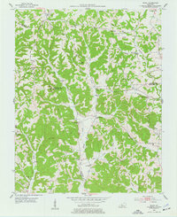
1953 Map of Ready
USGS Topo · Published 1977About this map
Big Reedy Creek and its many winding tributaries carve through the heart of this landscape at the intersection of Edmonson, Grayson, and Butler Counties. The settlement pattern is defined by hilltop communities and small hollows, where local life centered around a dense network of country schoolhouses and churches. Locations like Rabbit Flat and Windyville serve as central points for rural families, supported by institutions such as Hays Sch and Rabbit Flat Ch.
Find a feature on this map
43 named features on this map. Tap any name to fly to it.
Don’t see what you’re looking for? This feature index may not catch every label — zoom into the map to look around manually.
Map Details
Editions of this 1953 Ready Map
Other maps of this area

1914 · Little Muddy
USGS Topo · 1:62,500

1922 · Leitchfield
USGS Topo · 1:48,000

1922 · Brownsville
USGS Topo · 1:62,500

1923 · Brownsville
USGS Topo · 1:62,500

1925 · Spring Lick
USGS Topo · 1:62,500

1925 · Leitchfield
USGS Topo · 1:62,500

1953 · Ready
USGS Topo · 1:24,000

1953 · Bee Spring
USGS Topo · 1:24,000

1954 · Evansville
USGS Topo · 1:250,000

1954 · Spring Lick
USGS Topo · 1:24,000