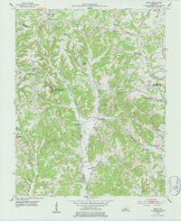
1953 Map of Ready
USGS Topo · Published 1984About this map
Big Reedy Creek and its many winding tributaries define the rural landscape of this 1950s Kentucky survey, where three counties—Grayson, Butler, and Edmonson—converge. Small agrarian settlements like Ready and Big Ready are connected by a network of unimproved roads and light-duty paths through heavily wooded terrain. This era shows a community anchored by a remarkably high density of rural schoolhouses and churches, such as Independence Sch, Sunny Point Sch 1, and Mt Pleasant Ch.
Find a feature on this map
45 named features on this map. Tap any name to fly to it.
Don’t see what you’re looking for? This feature index may not catch every label — zoom into the map to look around manually.
Map Details
Editions of this 1953 Ready Map
Other maps of this area

1914 · Little Muddy
USGS Topo · 1:62,500

1922 · Leitchfield
USGS Topo · 1:48,000

1922 · Brownsville
USGS Topo · 1:62,500

1923 · Brownsville
USGS Topo · 1:62,500

1925 · Spring Lick
USGS Topo · 1:62,500

1925 · Leitchfield
USGS Topo · 1:62,500

1953 · Ready
USGS Topo · 1:24,000

1953 · Bee Spring
USGS Topo · 1:24,000

1954 · Evansville
USGS Topo · 1:250,000

1954 · Spring Lick
USGS Topo · 1:24,000