
1950 Map of Red Bluff
USGS Topo · Published 1966About this map
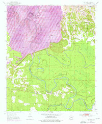
Little River carves a complex, winding path through the borderlands of Hempstead and Little River counties, defining a landscape dominated by oxbow lakes and meandering sloughs. In this 1950s era survey, the river is flanked by numerous named water bodies including Beard Lake, Cypress Lake, and the winding Bois d'Arc Bayou. The settlement of Saratoga serves as a local hub near the Saratoga Cemetery and Christian Church, while smaller locales like Red Bluff and Moore Camp sit along the tracks of the San Francisco railroad line.
Find a feature on this map
35 named features on this map. Tap any name to fly to it.
Don’t see what you’re looking for? This feature index may not catch every label — zoom into the map to look around manually.
Map Details
Editions of this 1950 Red Bluff Map
2 editions found
Other maps of this area

1950 · Ashdown East
USGS Topo · 1:24,000

1950 · Ogden
USGS Topo · 1:24,000

1950 · Ben Lomond
USGS Topo · 1:24,000

1951 · Ben Lomond
USGS Topo · 1:24,000

1951 · Ogden
USGS Topo · 1:24,000

1951 · Red Bluff
USGS Topo · 1:24,000

1951 · Ashdown East
USGS Topo · 1:24,000

1951 · Homan
USGS Topo · 1:24,000

1951 · Mineral Springs South
USGS Topo · 1:24,000

1951 · Fulton
USGS Topo · 1:24,000