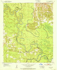
1951 Map of Red Bluff
USGS Topo · Published 1951About this map
The Little River and Saline River converge in a dense network of oxbows and swampy bottomlands in this 1951 study of the Hempstead and Little River county line. The landscape is defined by the winding river path, featuring numerous sloughs and cutoffs such as Cut-off Slough, Ground Bend, and Red Lake. This watery geography dictated the early transport patterns of the region, evidenced by the location of Ward Ferry (Abandoned) on a sharp bend of the Little River.
Find a feature on this map
40 named features on this map. Tap any name to fly to it.
Don’t see what you’re looking for? This feature index may not catch every label — zoom into the map to look around manually.
Map Details
Editions of this 1951 Red Bluff Map
2 editions found
Other maps of this area

1950 · Ashdown East
USGS Topo · 1:24,000

1950 · Ogden
USGS Topo · 1:24,000

1950 · Red Bluff
USGS Topo · 1:24,000

1950 · Ben Lomond
USGS Topo · 1:24,000

1951 · Ben Lomond
USGS Topo · 1:24,000

1951 · Ogden
USGS Topo · 1:24,000

1951 · Red Bluff
USGS Topo · 1:24,000

1951 · Ashdown East
USGS Topo · 1:24,000

1951 · Homan
USGS Topo · 1:24,000

1951 · Mineral Springs South
USGS Topo · 1:24,000