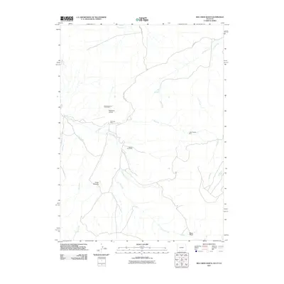
2011 Map of Red Creek Ranch
USGS Topo · Published 2011About this map
Star Numbers Five and Six Mine sits near the head of Telephone Canyon, marking a landscape defined by ranching and mineral exploration at the Wyoming-Utah border. This 2011 survey illustrates a network of drainage systems and isolated outposts, where seasonal water sources like Alkali Springs and Lizzie Spring Creek support the high-desert terrain. Scattered settlements and operations such as Red Creek Ranch, Meadow Gulch Ranch, and Petes Place are connected by a sparse road system including Aspen Mountain Rd. The presence of the John Erickson Dam on the upper reaches of Red Creek indicates the critical importance of water management for the sustainability of these remote ranching hubs during the early 21st century.
Find a feature on this map
20 named features on this map. Tap any name to fly to it.
Don’t see what you’re looking for? This feature index may not catch every label — zoom into the map to look around manually.
Map Details
Editions of this 2011 Red Creek Ranch Map
This is the sole edition of this map. No revisions or reprints were ever made.
Other maps of this area

1885 · Ashley
USGS Topo · 1:250,000

1952 · Willow Creek Butte
USGS Topo · 1:24,000

1952 · Clay Basin
USGS Topo · 1:24,000

1954 · Vernal
USGS Topo · 1:250,000

1954 · Rock Springs
USGS Topo · 1:250,000

1958 · Vernal
USGS Topo · 1:250,000

1958 · Rock Springs
USGS Topo · 1:250,000

1960 · Vernal
USGS Topo · 1:250,000

1962 · Rock Springs
USGS Topo · 1:250,000
1963 · Maxon Ranch
USGS Topo · 1:24,000