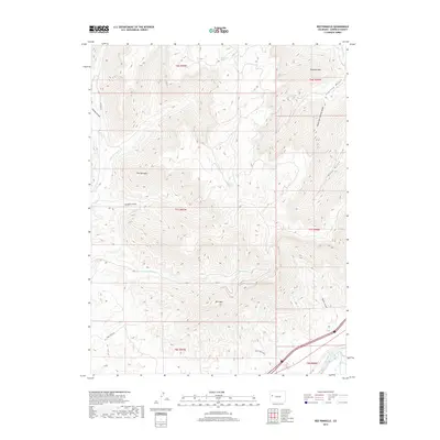
2019 Map of Red Pinnacle
USGS Topo · Published 2019About this map
Mt Logan and the prominent Red Pinnacle anchor this section of Garfield County, where the high desert plateau is deeply incised by drainages leading toward the Colorado River valley. The landscape is defined by its complex hydrography, featuring the perennial flow of Conn Creek and its East Fork, alongside essential water sources like Hayward Spring and Pritchard Spring. In the southeastern corner, the Colorado River corridor reveals a managed landscape where the Bluestone Valley Ditch directs water through the valley floor. Transportation and access are limited to a handful of routes such as Co HWY 213 and Conn Creek Road, which follow the natural contours of the gulches. The numerous named canyons, including Starkey Gulch and Bowdish Gulch, highlight the erosion patterns of the Piceance Basin margin as it descends toward the river basin.
Find a feature on this map
26 named features on this map. Tap any name to fly to it.
Don’t see what you’re looking for? This feature index may not catch every label — zoom into the map to look around manually.
Map Details
Editions of this 2019 Red Pinnacle Map
This is the sole edition of this map. No revisions or reprints were ever made.
Other maps of this area

1925 · Parachute Creek
USGS Topo · 1:62,500

1927 · Parachute Creek
USGS Topo · 1:62,500

1929 · Grand Valley
USGS Topo · 1:62,500

1929 · Highmore
USGS Topo · 1:62,500

1929 · Roan Creek
USGS Topo · 1:62,500

1956 · Grand Junction
USGS Topo · 1:250,000

1959 · Grand Junction
USGS Topo · 1:250,000

1960 · Grand Junction
USGS Topo · 1:250,000

1962 · Grand Junction
USGS Topo · 1:250,000
1962 · Grand Valley
USGS Topo · 1:24,000