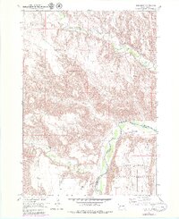
1951 Map of Red Shirt
USGS Topo · Published 1979About this map
Cheyenne River winds through this landscape, marking the northern boundary of the Pine Ridge Indian Reservation where it meets the border of Custer and Shannon Counties. The small community of Red Shirt is positioned near the river's edge, serving as a focal point for the surrounding Pine Ridge and Table terrain. This 1951 survey, updated in the late 1970s, illustrates the complex drainage system of the region, where Battle Creek, Red Shirt Creek, and French Creek converge toward the main river valley.
Find a feature on this map
13 named features on this map. Tap any name to fly to it.
Don’t see what you’re looking for? This feature index may not catch every label — zoom into the map to look around manually.
Map Details
Editions of this 1951 Red Shirt Map
3 editions found
Other maps of this area

1894 · Hermosa
USGS Topo · 1:125,000

1901 · Hermosa
USGS Topo · 1:125,000

1951 · Fairburn SE
USGS Topo · 1:24,000

1951 · Red Shirt
USGS Topo · 1:24,000

1951 · Red Shirt NE
USGS Topo · 1:24,000

1951 · Red Shirt SW
USGS Topo · 1:24,000

1951 · Cuny Table West
USGS Topo · 1:24,000

1953 · Hermosa SE
USGS Topo · 1:24,000

1953 · Folsom
USGS Topo · 1:24,000

1953 · Caputa SW
USGS Topo · 1:24,000