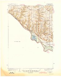
1944 Map of Red Wing
USGS Topo · Published 1944About this map
The Mississippi River valley forms a dramatic southwest border for this 1938 survey, where the river's path is defined by a series of bluffs and complex backwaters including Upper Lake and Lower Lake. The Chicago Burlington and Quincy railroad tracks hug the shoreline, connecting small riverfront settlements like Diamond Bluff and Smith Landing. Inland, the landscape of Pierce County is divided into a network of coulees and ridges, with drainage provided by the Trimbelle River and Spring Creek.
Find a feature on this map
48 named features on this map. Tap any name to fly to it.
Don’t see what you’re looking for? This feature index may not catch every label — zoom into the map to look around manually.
Map Details
Editions of this 1944 Red Wing Map
2 editions found
Other maps of this area

1940 · Maiden Rock
USGS Topo · 1:62,500

1944 · Red Wing
USGS Topo · 1:62,500

1946 · Hudson
USGS Topo · 1:62,500

1946 · River Falls
USGS Topo · 1:62,500

1949 · River Falls
USGS Topo · 1:62,500

1949 · Hudson
USGS Topo · 1:62,500

1949 · Baldwin
USGS Topo · 1:62,500

1950 · Maiden Rock
USGS Topo · 1:62,500

1951 · Prescott
USGS Topo · 1:24,000

1951 · Lake City
USGS Topo · 1:62,500