
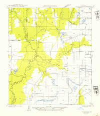
1947 Map of Redland
USGS Topo · Published 1947About this map
Eunice anchors the southern edge of this mid-century survey, situated at the junction of several major rail lines that once drove the region's agricultural economy. The landscape is defined by the winding course of Bayou des Cannes, which marks the boundary between Evangeline and St. Landry Parish. The surveyor's work captures a rural network of prairie settlements and crossroads before the widespread consolidation of the later 20th century.
Find a feature on this map
24 named features on this map. Tap any name to fly to it.
Don’t see what you’re looking for? This feature index may not catch every label — zoom into the map to look around manually.
Map Details
Editions of this 1947 Redland Map
This is the sole edition of this map. No revisions or reprints were ever made.
Other maps of this area

1947 · Ville Platte
USGS Topo · 1:31,680

1947 · Fruge Lake
USGS Topo · 1:31,680

1947 · Chataignier
USGS Topo · 1:31,680

1947 · Bond
USGS Topo · 1:31,680

1947 · Eunice
USGS Topo · 1:31,680

1947 · Pitreville
USGS Topo · 1:31,680

1947 · Basile
USGS Topo · 1:31,680

1949 · Basile
USGS Topo · 1:31,680

1952 · Lake Charles
USGS Topo · 1:250,000
1954 · Fruge Lake
USGS Topo · 1:31,680