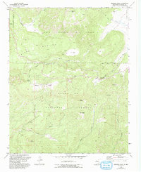
1970 Map of Redondo Peak
USGS Topo · Published 1993About this map
Baca Location No 1 Grant dominates the northern half of this landscape, showcasing the historic Spanish land grant boundaries that still influence modern property lines in New Mexico. The high volcanic terrain of Redondo Peak rises above several deep canyons, including San Juan Canyon and Peralta Canyon, which dictate the movement of both water and traveler.
Find a feature on this map
35 named features on this map. Tap any name to fly to it.
Don’t see what you’re looking for? This feature index may not catch every label — zoom into the map to look around manually.
Map Details
Editions of this 1970 Redondo Peak Map
4 editions found
Other maps of this area

1890 · Jemes
USGS Topo · 1:125,000

1892 · Jemes
USGS Topo · 1:125,000

1892 · Santa Clara
USGS Topo · 1:125,000

1937 · Jemez Springs
USGS Topo · 1:48,000

1943 · Jemez
USGS Topo · 1:62,500

1944 · Jemez Springs
USGS Topo · 1:62,500

1952 · Valle Toledo
USGS Topo · 1:24,000

1952 · Jemez Springs
USGS Topo · 1:62,500

1952 · Jemez
USGS Topo · 1:62,500

1953 · Bland
USGS Topo · 1:24,000