
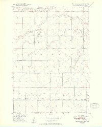
1950 Map of Ree Heights SE
USGS Topo · Published 1950About this map
Moncur Sch and several other rural schoolhouses define the dispersed educational landscape of Hand County at the midpoint of the twentieth century. The eastern edge of the quadrangle touches Miller, where the Odd Fellows Cem is located near the Chicago and North Western railroad line. This rail corridor serves as the primary East-West axis through the southern portion of the survey, connecting the townships of Midland and Miller.
Find a feature on this map
16 named features on this map. Tap any name to fly to it.
Don’t see what you’re looking for? This feature index may not catch every label — zoom into the map to look around manually.
Map Details
Editions of this 1950 Ree Heights SE Map
2 editions found
Other maps of this area

1899 · Redfield
USGS Topo · 1:125,000

1949 · Ree Heights NW
USGS Topo · 1:24,000

1950 · Vayland NW
USGS Topo · 1:24,000

1950 · Ree Heights
USGS Topo · 1:24,000

1951 · Ree Heights NW
USGS Topo · 1:24,000

1951 · Ree Heights NE
USGS Topo · 1:24,000

1953 · Huron
USGS Topo · 1:250,000

1954 · Huron
USGS Topo · 1:250,000

1967 · Miller
USGS Topo · 1:24,000
1967 · Miller NW
USGS Topo · 1:24,000