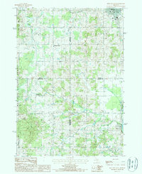
1987 Map of Reed City South
USGS Topo · Published 1987About this map
The Muskegon River flows through the southeastern corner of this landscape, marking the transition from the rolling timberlands of the Manistee National Forest in the west to the more settled river valleys. The 1980s terrain is defined by a dense network of tributaries including the Middle Branch Pere Marquette River, Buckhorn Creek, and Paris Creek, reflecting the region's glacial topography. Human settlement is concentrated at the northern edge in Reed City and at the southern reach near Paris, where a prominent Fish Hatchery and Trailer Park are noted. Interior points like Kellars Corners and Hawkins represent the quiet rural crossroads of the era, while scattered Cem labels provide valuable reference points for genealogists tracing local families in the wooded townships of Chase, Richmond, Barton, and Green.
Find a feature on this map
23 named features on this map. Tap any name to fly to it.
Don’t see what you’re looking for? This feature index may not catch every label — zoom into the map to look around manually.
Map Details
Editions of this 1987 Reed City South Map
This is the sole edition of this map. No revisions or reprints were ever made.
Other maps of this area

1931 · Chase NE
USGS Topo · 1:31,680

1932 · Chase NW
USGS Topo · 1:31,680

1954 · Midland
USGS Topo · 1:250,000

1958 · Midland
USGS Topo · 1:250,000

1958 · Woodville
USGS Topo · 1:62,500

1958 · Big Rapids
USGS Topo · 1:62,500

1959 · Midland
USGS Topo · 1:250,000

1959 · Evart
USGS Topo · 1:62,500

1959 · Reed City
USGS Topo · 1:62,500

1966 · Midland
USGS Topo · 1:250,000