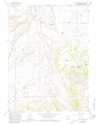
1964 Map of Reed Reservoir
USGS Topo · Published 1981About this map
Cottonwood Creek and its many tributaries carve through the high plains of Uinta County in this detailed mid-century survey. The landscape is defined by an extensive water management system essential for high-altitude ranching, featuring numerous small catchments like Whisky Reservoir, Clematis Reservoir, and Reed Reservoir. The rugged drainage patterns of Crooked Canyon and Dry Wash are contrasted by the prominent elevation of Sage Creek Mountain and the broad expanse of Cottonwood Bench. Human activity is marked by the presence of a Gravel Pit near the southern boundary and a network of unimproved routes, including the Cedar Mountain Road and various Jeep Trails, which provided vital access for land use in this open Wyoming terrain before modern development intensified.
Find a feature on this map
21 named features on this map. Tap any name to fly to it.
Don’t see what you’re looking for? This feature index may not catch every label — zoom into the map to look around manually.
Map Details
Editions of this 1964 Reed Reservoir Map
2 editions found
Other maps of this area

1954 · Ogden
USGS Topo · 1:250,000

1958 · Ogden
USGS Topo · 1:250,000

1960 · Ogden
USGS Topo · 1:250,000

1964 · Butcher Knife Draw
USGS Topo · 1:24,000

1964 · Soap Holes Reservoir
USGS Topo · 1:24,000

1964 · Reed Reservoir
USGS Topo · 1:24,000

1964 · Mountain View
USGS Topo · 1:24,000
1964 · Lonetree
USGS Topo · 1:24,000
1964 · Table Mountain
USGS Topo · 1:24,000
1964 · Burntfork
USGS Topo · 1:24,000