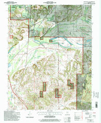
1996 Map of Reevesville
USGS Topo · Published 1998About this map
The Illinois Central RR corridor serves as a central spine for this 1990s landscape, connecting the town of Reevesville to northern points near Renshaw. This region, where the borders of Johnson, Pope, and Massac counties converge, is defined by the complex water systems of Bay Creek, Sugar Creek, and the Black Slough. Significant engineering is evident along the waterways, where an extensive Levee system protects the low-lying terrain from the seasonal fluctuations of Old Bay and Big Bay.
Find a feature on this map
35 named features on this map. Tap any name to fly to it.
Don’t see what you’re looking for? This feature index may not catch every label — zoom into the map to look around manually.
Map Details
Editions of this 1996 Reevesville Map
This is the sole edition of this map. No revisions or reprints were ever made.
Other maps of this area

1917 · Brownfield
USGS Topo · 1:62,500

1918 · Vienna
USGS Topo · 1:62,500

1919 · Vienna
USGS Topo · 1:62,500

1926 · Paducah
USGS Topo · 1:62,500

1928 · La Center
USGS Topo · 1:62,500

1929 · Paducah
USGS Topo · 1:62,500

1932 · La Center
USGS Topo · 1:62,500

1940 · Paducah
USGS Topo · 1:62,500

1942 · Vienna
USGS Topo · 1:62,500

1949 · Paducah
USGS Topo · 1:250,000