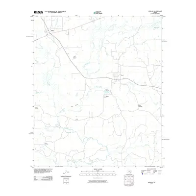
2010 Map of Reklaw
USGS Topo · Published 2010About this map
The Angelina River and its intricate network of tributaries, including White Oak Creek and Mud Creek, dominate this East Texas landscape between the communities of Reklaw and Sacul. This 2010 survey illustrates a region defined by its bottomlands and sloughs, such as Rutherford Slough and Boatman Slough, which contrast with local elevations like Beard Mountain. Significant for genealogists, the map preserves the locations of three distinct burial grounds: Looney Cemetery, Ward Cemetery, and Martin Cemetery. The area around Dextra shows a landscape of scattered lakes and dams, specifically Lucas Lake and its associated Lucas Lake Dam. Further south, the course of the river creates distinctive features like Pine Island and feeds into Jolly Lake, while the Flying M Ranch Airport serves as a modern waypoint in this largely rural expanse of Nacogdoches County.
Find a feature on this map
26 named features on this map. Tap any name to fly to it.
Don’t see what you’re looking for? This feature index may not catch every label — zoom into the map to look around manually.
Map Details
Editions of this 2010 Reklaw Map
This is the sole edition of this map. No revisions or reprints were ever made.
Other maps of this area

1943 · Cushing
USGS Topo · 1:62,500

1943 · Rusk
USGS Topo · 1:62,500

1945 · Cushing
USGS Topo · 1:62,500

1945 · Rusk
USGS Topo · 1:62,500

1946 · Alto
USGS Topo · 1:62,500

1952 · Douglass
USGS Topo · 1:62,500

1953 · Palestine
USGS Topo · 1:250,000

1957 · Palestine
USGS Topo · 1:250,000
1973 · New Summerfield
USGS Topo · 1:24,000

1973 · Cushing
USGS Topo · 1:24,000