
1927 Map of Remington
USGS Topo · Published 1927About this map
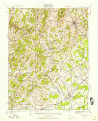
The Rappahannock River carves a winding boundary between Fauquier Co and Culpeper Co in this 1927 survey, documenting a landscape of rural hamlets and upland farms. The town of Warrenton serves as a prominent hub in the northeast, while the Southern railroad corridor connects the settlements of Bealeton and Remington to the southeast. A notable concentration of social history is preserved through the numerous country schools and churches, such as Luttrell Sch, Piney Ridge Sch, and Westley Chapel. Along the river's edge, the Fauquier Sulphur Springs stands as a landmark of the region's resort history. The presence of the Lee Highway crossing through Amissville and Waterloo illustrates the early development of modern automobile thoroughfares through the older agrarian network of Carter Run and Hazel River.
Find a feature on this map
51 named features on this map. Tap any name to fly to it.
Don’t see what you’re looking for? This feature index may not catch every label — zoom into the map to look around manually.
Map Details
Editions of this 1927 Remington Map
4 editions found

Other maps of this area

1887 · Spottsylvania
USGS Topo · 1:125,000

1892 · Spottsylvania
USGS Topo · 1:125,000

1892 · Gordonsville
USGS Topo · 1:125,000

1893 · Luray
USGS Topo · 1:125,000

1894 · Warrenton
USGS Topo · 1:125,000

1894 · Warrenton
USGS Topo · 1:62,500

1905 · Luray
USGS Topo · 1:125,000

1930 · Warrenton
USGS Topo · 1:62,500

1933 · Middleburg
USGS Topo · 1:62,500

1939 · Front Royal
USGS Topo · 1:48,000