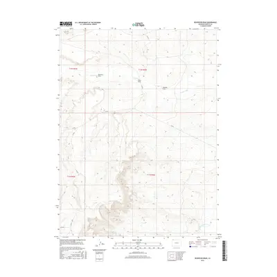
2016 Map of Reservoir Draw
USGS Topo · Published 2016About this map
Reservoir Draw and the surrounding high desert of Moffat County characterize this 2016 survey, where the drainages of Powder Wash and Horse Draw carve through the arid terrain of northwestern Colorado. The landscape is defined by its water-scarce geography, marked by the presence of Reservoir Spring and the meandering course of the Little Snake River at the southern boundary. This era of the landscape is dominated by a network of county roads, including Co Rd 163 and Co Rd 66, which provide the primary access through these remote public and private land sections. The topography is detailed through various named draws, such as Ruedloff Draw, illustrating a complex system of seasonal runoff channels that shape the regional basin.
Find a feature on this map
14 named features on this map. Tap any name to fly to it.
Don’t see what you’re looking for? This feature index may not catch every label — zoom into the map to look around manually.
Map Details
Editions of this 2016 Reservoir Draw Map
This is the sole edition of this map. No revisions or reprints were ever made.
Other maps of this area

1954 · Vernal
USGS Topo · 1:250,000

1954 · Rock Springs
USGS Topo · 1:250,000

1958 · Vernal
USGS Topo · 1:250,000

1958 · Rock Springs
USGS Topo · 1:250,000

1960 · Vernal
USGS Topo · 1:250,000

1962 · Rock Springs
USGS Topo · 1:250,000

1969 · Reservoir Draw
USGS Topo · 1:24,000
1969 · The Nipple SE
USGS Topo · 1:24,000

1969 · The Nipple
USGS Topo · 1:24,000
1969 · The Nipple NE
USGS Topo · 1:24,000