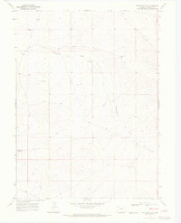
1969 Map of The Nipple SE
USGS Topo · Published 1972About this map
Greasewood Gulch and the seasonal drainage of Red Wash define this arid landscape in Moffat County, where land use in the late 1960s was dominated by ranching and resource exploration. A isolated Corral and a scattered network of Drill Hole sites suggest a geography focused on both livestock management and mineral prospecting. Water access in this dry terrain is highlighted by a specific Flowing Well and several Spring points, which likely served as critical landmarks for locals moving through the sagebrush and gulches. The elevation rises toward the prominent Red Wash Butte in the southwestern corner, providing a clear view of the complex topographical contours that characterize this high-desert region of Northwest Colorado.
Find a feature on this map
7 named features on this map. Tap any name to fly to it.
Don’t see what you’re looking for? This feature index may not catch every label — zoom into the map to look around manually.
Map Details
Editions of this 1969 The Nipple SE Map
2 editions found
Other maps of this area

1916 · Craig
USGS Topo · 1:125,000

1954 · Vernal
USGS Topo · 1:250,000

1954 · Craig
USGS Topo · 1:250,000

1957 · Craig
USGS Topo · 1:250,000

1958 · Vernal
USGS Topo · 1:250,000

1958 · Craig
USGS Topo · 1:250,000

1958 · Maybell
USGS Topo · 1:62,500

1960 · Craig
USGS Topo · 1:250,000

1960 · Vernal
USGS Topo · 1:250,000

1962 · Craig
USGS Topo · 1:250,000