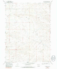
1969 Map of The Nipple SE
USGS Topo · Published 1986About this map
Greasewood Gulch cuts a deep, winding path through this corner of Moffat County, defining a landscape marked by arid drainages and isolated water sources. This 1969 field check reveals a territory primarily utilized for resource extraction and livestock, evidenced by the presence of a Corral and several widely spaced Drill Holes. The topography is anchored in the southwest by Red Wash Butte, which overlooks the ephemeral Red Wash. Reliance on sparse water is a clear theme of the era, with only a few locations like a Flowing Well and an occasional Spring providing reliable points for cattle or exploration. The network of unimproved roads and lack of formal settlements emphasize the utilitarian, open-range character of the high desert at the end of the 1960s.
Find a feature on this map
7 named features on this map. Tap any name to fly to it.
Don’t see what you’re looking for? This feature index may not catch every label — zoom into the map to look around manually.
Map Details
Editions of this 1969 The Nipple SE Map
2 editions found
Other maps of this area

1916 · Craig
USGS Topo · 1:125,000

1954 · Vernal
USGS Topo · 1:250,000

1954 · Craig
USGS Topo · 1:250,000

1957 · Craig
USGS Topo · 1:250,000

1958 · Vernal
USGS Topo · 1:250,000

1958 · Craig
USGS Topo · 1:250,000

1958 · Maybell
USGS Topo · 1:62,500

1960 · Craig
USGS Topo · 1:250,000

1960 · Vernal
USGS Topo · 1:250,000

1962 · Craig
USGS Topo · 1:250,000