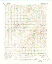
1961 Map of Reydon
USGS Topo · Published 1980About this map
The Washita River and Panhandle and Santa Fe railroad corridor define this western Oklahoma landscape along the Texas border in the early 1960s. Rural life in Roger Mills County centers on small hubs like Reydon, Rankin, and Dempsey, which serve a territory divided into township blocks such as Bowman and Streeter. For genealogists, the map is an excellent resource for locating family burial plots, including Union Chapel Cem, White Rose Cem, and Dempsey Cem, which are often the only remaining markers of vanished pioneer communities. The terrain is deeply dissected by a network of waterways including Rush Creek, Croton Creek, and East Croton Creek, showing the erosion patterns common to this part of the plains. Farther south, the map details the community of Berlin and landmarks like the Community Hall, providing a clear record of the area's infrastructure before many rural schools and civic centers consolidated.
Find a feature on this map
28 named features on this map. Tap any name to fly to it.
Don’t see what you’re looking for? This feature index may not catch every label — zoom into the map to look around manually.
Map Details
Editions of this 1961 Reydon Map
3 editions found
Other maps of this area

1954 · Amarillo
USGS Topo · 1:250,000

1955 · Clinton
USGS Topo · 1:250,000

1957 · Clinton
USGS Topo · 1:250,000

1958 · Amarillo
USGS Topo · 1:250,000

1960 · Sweetwater
USGS Topo · 1:62,500

1960 · Cheyenne
USGS Topo · 1:62,500

1960 · Sayre
USGS Topo · 1:62,500

1961 · Reydon
USGS Topo · 1:62,500

1963 · Allison
USGS Topo · 1:24,000

1963 · Kelton
USGS Topo · 1:24,000