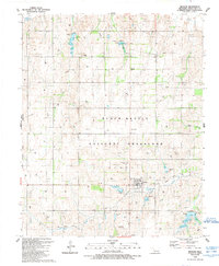
1989 Map of Reydon
USGS Topo · Published 1989About this map
The Black Kettle National Grassland dominates this portion of Roger Mills County, illustrating a landscape defined by federal conservation efforts and the transition from prairie to managed range. Near the northern boundary, the Washita River meanders through the terrain, while further south, Skipout Lake serves as a significant water feature with its associated Boat Ramp. The map captures the infrastructure of the late-century energy economy, marked by a dense network of Gas Well sites and underground Pipeline corridors. Historical settlement patterns are visible at Midway and Rankin, alongside the legacy of the Old Railroad Grade which once served the region. For genealogists, the Union Chapel Cem stands as a primary landmark for family history research. The presence of the Cary Ranch Landing Strip and a Radio Tower reflect the modern utility of this wide-open Oklahoma landscape.
Find a feature on this map
29 named features on this map. Tap any name to fly to it.
Don’t see what you’re looking for? This feature index may not catch every label — zoom into the map to look around manually.
Map Details
Editions of this 1989 Reydon Map
This is the sole edition of this map. No revisions or reprints were ever made.
Other maps of this area

1954 · Amarillo
USGS Topo · 1:250,000

1955 · Clinton
USGS Topo · 1:250,000

1957 · Clinton
USGS Topo · 1:250,000

1958 · Amarillo
USGS Topo · 1:250,000

1961 · Reydon
USGS Topo · 1:62,500

1963 · Allison
USGS Topo · 1:24,000

1965 · Crawford
USGS Topo · 1:24,000

1966 · Durham
USGS Topo · 1:24,000

1967 · Gem
USGS Topo · 1:24,000

1967 · Hackberry Creek
USGS Topo · 1:24,000