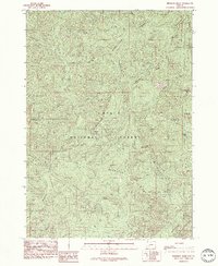
1989 Map of Reynolds Ridge
USGS Topo · Published 1990About this map
Homestead Ridge and Reynolds Ridge dominate this rugged landscape within the Umpqua National Forest and Willamette National Forest. Surveyed in the 1980s, the map reveals a wilderness area defined by steep drainages and isolated landmarks like Granddad Butte and Buster Butte. The boundary between Lane Co and Douglas Co cuts through the center of the sheet, where high-elevation points such as Firemans Leap and Pyramid Rock watch over the headwaters of numerous creeks. Small traces of human presence are recorded at Grassy Ranch Camp, Reynolds Shelter, and the Bullpup Lake area, though the terrain is largely defined by its primitive nature. The southern portion includes part of the Boulder Creek Wilderness, highlighting the area's role as a protected forest habitat before the turn of the century.
Find a feature on this map
32 named features on this map. Tap any name to fly to it.
Don’t see what you’re looking for? This feature index may not catch every label — zoom into the map to look around manually.
Map Details
Editions of this 1989 Reynolds Ridge Map
2 editions found
Other maps of this area

1917 · Diamond Lake
USGS Topo · 1:125,000

1925 · Waldo Lake
USGS Topo · 1:125,000

1935 · Lowell
USGS Topo · 1:96,000

1942 · Lowell
USGS Topo · 1:125,000

1955 · Illahee Rock
USGS Topo · 1:62,500

1955 · Fairview Peak
USGS Topo · 1:62,500

1956 · Toketee Falls
USGS Topo · 1:62,500

1956 · Oakridge
USGS Topo · 1:62,500

1958 · Roseburg
USGS Topo · 1:250,000

1959 · Roseburg
USGS Topo · 1:250,000