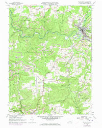
1966 Map of Reynoldsville
USGS Topo · Published 1973About this map
Reynoldsville serves as the industrial and residential hub of this Jefferson County landscape, situated along the winding course of Sandy Lick Creek. During the mid-1960s, the region was defined by a complex extraction economy, evidenced by the numerous Gas Wells and extensive Strip Mine operations that pockmark the hillsides between the boroughs. The Penn Central railroad corridors facilitate movement through the townships of Winslow, Pine Creek, and McCalmont, connecting established settlements like Soldier and Wishaw.
Find a feature on this map
51 named features on this map. Tap any name to fly to it.
Don’t see what you’re looking for? This feature index may not catch every label — zoom into the map to look around manually.
Map Details
Editions of this 1966 Reynoldsville Map
4 editions found
Other maps of this area

1906 · Punxsutawney
USGS Topo · 1:62,500

1909 · Smicksburg
USGS Topo · 1:62,500

1922 · Du Bois
USGS Topo · 1:62,500

1924 · Du Bois
USGS Topo · 1:62,500

1924 · Brookville
USGS Topo · 1:62,500

1926 · Brookville
USGS Topo · 1:62,500

1938 · Smicksburg
USGS Topo · 1:62,500

1939 · Smicksburg
USGS Topo · 1:62,500

1939 · Punxsutawney
USGS Topo · 1:62,500

1942 · Punxsutawney
USGS Topo · 1:62,500
Featured Places
- Reynoldsville, PA
- Pine Creek Township, PA
- Knox Township, PA
- Winslow Township, PA
- Anita, McCalmont Township