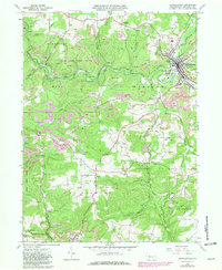
1966 Map of Reynoldsville
USGS Topo · Published 1981About this map
Sandy Lick Creek carves a deep valley through the high plateaus of Jefferson County, centering on the borough of Reynoldsville. By the mid-1960s, the landscape reflects a complex history of extraction and recovery, where extensive Strip Mine operations and numerous Gas Wells sit alongside the expansive forests of State Game Lands No 244. The settlement pattern follows both the water and the ridges, from the industrial periphery of the borough to rural outposts with evocative names like Panic and Desire.
Find a feature on this map
53 named features on this map. Tap any name to fly to it.
Don’t see what you’re looking for? This feature index may not catch every label — zoom into the map to look around manually.
Map Details
Editions of this 1966 Reynoldsville Map
4 editions found
Other maps of this area

1906 · Punxsutawney
USGS Topo · 1:62,500

1909 · Smicksburg
USGS Topo · 1:62,500

1922 · Du Bois
USGS Topo · 1:62,500

1924 · Du Bois
USGS Topo · 1:62,500

1924 · Brookville
USGS Topo · 1:62,500

1926 · Brookville
USGS Topo · 1:62,500

1938 · Smicksburg
USGS Topo · 1:62,500

1939 · Smicksburg
USGS Topo · 1:62,500

1939 · Punxsutawney
USGS Topo · 1:62,500

1942 · Punxsutawney
USGS Topo · 1:62,500
Featured Places
- Reynoldsville, PA
- Pine Creek Township, PA
- Knox Township, PA
- Winslow Township, PA
- Anita, McCalmont Township