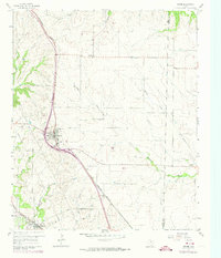
1960 Map of Rhome
USGS Topo · Published 1974About this map
The Burlington Northern railroad corridor dictates the settlement pattern of this North Texas landscape, connecting the communities of Rhome and Newark as they appeared in the early 1960s. This survey, updated with late-era revisions, captures the agrarian transition of the region where the Wise and Denton County line crosses rolling prairie. Local history is anchored by sites like Fairview Church and the nearby Fairview Cemetery, while the Aurora Cemetery sits on the western edge of the quadrangle. A network of waterways, including Elizabeth Creek, Harriet Creek, and Hackberry Creek, carves through the terrain, illustrating the natural drainage systems that historically shaped land use before modern expansion. The map also records the presence of smaller locales such as Bryan and Fairview, providing a clear view of the rural infrastructure and property divisions of the mid-twentieth century.
Find a feature on this map
18 named features on this map. Tap any name to fly to it.
Don’t see what you’re looking for? This feature index may not catch every label — zoom into the map to look around manually.
Map Details
Editions of this 1960 Rhome Map
3 editions found

Other maps of this area

1891 · Weatherford
USGS Topo · 1:125,000

1893 · Weatherford
USGS Topo · 1:125,000

1894 · Fort Worth
USGS Topo · 1:125,000

1924 · Sunset 4-d
USGS Topo · 1:48,000

1930 · Boyd
USGS Topo · 1:62,500

1932 · Springtown
USGS Topo · 1:62,500

1954 · Dallas
USGS Topo · 1:250,000

1954 · Sherman
USGS Topo · 1:250,000

1955 · Avondale
USGS Topo · 1:24,000

1955 · Azle
USGS Topo · 1:24,000