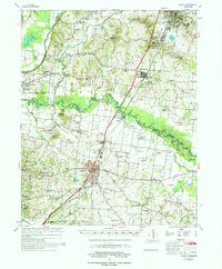
1977 Map of Rialto
USGS Topo · Published 1977About this map
The Hatchie River carves a winding path through the borderlands of Lauderdale County and Tipton County, anchoring a landscape of bottomlands and rural communities in the 1970s. The regional center of Covington shows significant infrastructure development, including the Covington Municipal Airport and the Vocational Sch. To the northwest, the Fort Pillow State Farm occupies the higher ground near Cold Creek, reflecting the area's mix of state institutions and agriculture.
Find a feature on this map
100 named features on this map. Tap any name to fly to it.
Don’t see what you’re looking for? This feature index may not catch every label — zoom into the map to look around manually.
Map Details
Editions of this 1977 Rialto Map
This is the sole edition of this map. No revisions or reprints were ever made.
Other maps of this area
1939 · Hales Point
USGS Topo · 1:62,500
1939 · Halls
USGS Topo · 1:62,500
1939 · Blytheville
USGS Topo · 1:62,500
1942 · Millington
USGS Topo · 1:62,500
1952 · Stanton
USGS Topo · 1:24,000
1952 · Hales Point
USGS Topo · 1:62,500
1952 · Gates
USGS Topo · 1:24,000
1952 · Stanton
USGS Topo · 1:62,500
1954 · Mason
USGS Topo · 1:62,500
1955 · Blytheville
USGS Topo · 1:62,500